Tab: Automator#
The Automator Tab allows you to automate repetitive tasks directly from the plugin such as adding fields to the shoreline layer and baseline layer.
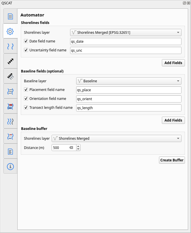
Fig. 4 User interface of Automator Tab#
Shorelines#
Shorelines fields#
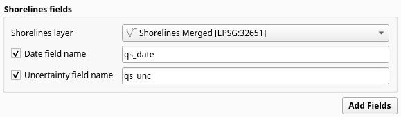
Fig. 5 Shorelines fields section in Automator Tab#
The Shorelines fields automator simplifies the process of adding attributes by automatically assigning pre-defined data types and custom field names. By simply defining the desired field name, the plugin takes care of the necessary data type assignments for each field. This requires the following input:
Input layer: vector layer containing the merged shorelines.
Date field name: field name that represents the date of the source of shoreline data, following the format
mm/yyyy.Uncertainty field name: field name that captures the uncertainty associated with the measurement and/or positional accuracy inherent in the source of shoreline data.
The automator adds the following fields to the input layer:
Field name |
Data type |
|---|---|
|
|
|
|
Without the automator, the date and uncertainty fields can be manually added on the of the shoreline input layer. Basically, this means that you are responsible for selecting the attribute data type. To check full details about shorelines layer, please refer to the Shoreline vectors preparation.
Baseline#
Baseline fields#
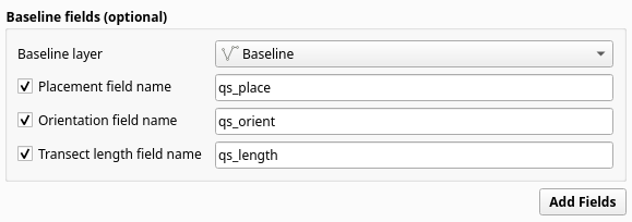
Fig. 6 Baseline fields section in Automator Tab#
The Baseline fields automator simplifies the process of adding attributes by automatically assigning pre-defined data types and custom field names. By simply defining the desired field name, the plugin takes care of the necessary data type assignments for each field. This requires the following input:
Input layer: vector layer containing the merged baseline.
Placement field name: field name that represents placement of baseline.
Orientation field name: field name that captures the orientation of the baseline.
Transect length name: field name that captures the length of the transect.
The automator adds the following fields to the input layer:
Field name |
Data type |
|---|---|
|
|
|
|
|
|
For more information about these fields, please refer to Optional multiple baseline vectors in one layer.
Baseline buffer#
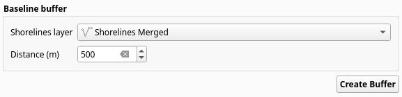
Fig. 7 Baseline buffer section in Automator Tab#
The Baseline buffer automator simplifies the process of creating a buffer around the baseline. This requires the following input:
Input layer: vector layer containing the merged shorelines.
Buffer distance: distance in meters to create the buffer around the baseline.
The automator uses processing algorithm Buffer with pre-defined inputs to create the buffer around the merged shorelines layer. The output is then converted to LineString. To read more about input baseline layer, please refer to Baseline vectors creation.
The following are the pre-defined inputs for the Buffer algorithm:
Parameter |
Value |
|---|---|
Distance |
|
Segments |
5 |
End cap style |
Flat |
Join style |
Round |
|
Checked |
